Generally,three issues are the most focused by 3D modeling artists:
First of all,we talk about the most concerned question for 3D modeling artists :how to connect roads and terrain
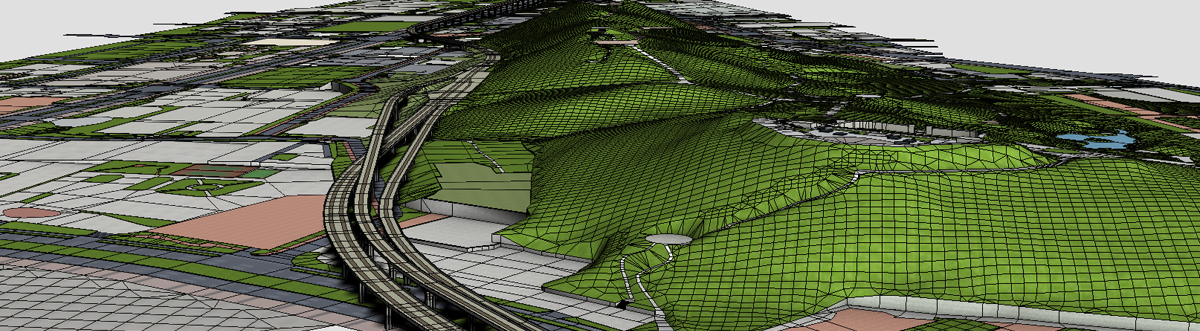
Connect roads and terrains
There are two main ways to connect roads and terrains:
For an existed terrain object(such as a terrain mesh built from contour lines or some DEM data),thinking about the work flow:first ,delete the faces covered by the roads,then we can get some borders,with the borders and that of the roads ,create a big polygon face and subdivide it,then we will complete connecting.
In TerrainAxe,CapEdges,FreePoly can use an unclosed border to create a polygon,StitchVerts and Triangulate(Faces) can cut polygons.
We can also use StitchPoly directly to create polygons to connect borders of a terrain and a road.
Use StitchVerts connect roads and terrains
2.For those areas enclosed or semi-enclosed by roads,maybe the original terrain is missing or un-useful,a new terrain need to be re-created. Thus you can cap these areas to create a new polygon,then use Slice to cut and get grid-like topology,then relax them or paint desired appearance with 3dsmax's brush tools .
Create terrain with Slice
the way is also suit for the first situation.If you don't like the topology created with contour lines,you can use MoveVerts to conform vertices of the grid-like faces to the original terrain.So,you don't need to stitch them.
Use MoveVerts re-construct terrain
Topologize
Topologizing is very important.To present accurate slopes and road levles, topologizing or re-topologizing is necessary.There are some requirements for topologizing:
A road should be made up of regulate quad polygons as much as possible,as shown below in left picture;Some ground pavement need some cutting operations to make the polygon topology more reasonable;
Narrow and long triangles should be avoided as much as possible. The more reasonable topology, the better the effect at render time, as shown below in the right picture.
Good topology1 | Good topology2 |
To meet the above requirements,many cutting operations are needed.In TerrainAxe ,there are many cutting tools to such as CutPerToEdge,CutByAgl,Cut2Verts and StitchVerts,and so on
Cut perpendicularly to edge | Cut along angular bisector | Connect two vertex team |
Slope modeling and road smoothing
Make a Slope
Such a tool is indispensable:when vertices of surface fall to a slope,only z coordinates are modified but xy coordinates keep unchanged,that is ,make vertices align to slope plane along Z axis ,or the structure in top view will be damaged.MoveVerts can do this.
Slope landscape
Smooth Roads
To present road levels and get a natural appearance,the section of a road need to keep horizontal,and can't be sticked to the terrain like a clothe .
So an ideal tool should be able to output a smooth transition like a curve and meanwhile be able to map the evelation data of one side of the road to that of the other side,
When smoothing a road ,continous edges can be used to represent a range of the road and the vertices with different z coordinates to express different elevations
you can use SMRoad(linear),SMRoad(curve),SMRoad(npts),SMRoad(blur) to complete this work.
SMRoad(Splines) uses a more advanced way to smooth a road in which you can ajust knots of splines to control the transition.
Use SMRoad(blur)to smooth a road
The article describe several main issuses of terrain modeling from the outer frame,it should be as a main direction.Hope readers can get desired help and have a good beginning.